Day 2 of the Incredible Iceland (South) trip was here.
We checked out of the Hotel Vik and were on our way to our first location.
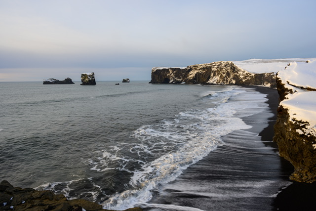
Dryholaey (“Dirro-lay”)
About Dryholaey
Dyrhólaey (“door hill island”), formerly known by seamen as Cape Portland, is a small promontory located on the south coast of Iceland, not far from the village of Vik.
To the east, the black lava columns of the Reynisdrangar come out of the sea.
It is commonly asserted that Dyrhólaey is the most southernly point in Iceland.
The Shoot
On the short walk from the car park, you soon see the view ahead of the Reynisdrangar stacks.
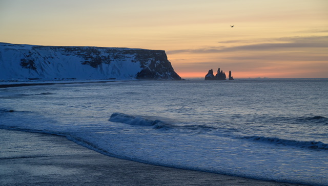
I took a few shots from the clifftop then walked up the path to a slightly higher viewpoint.
The following shot grabs the curvature of the beach.
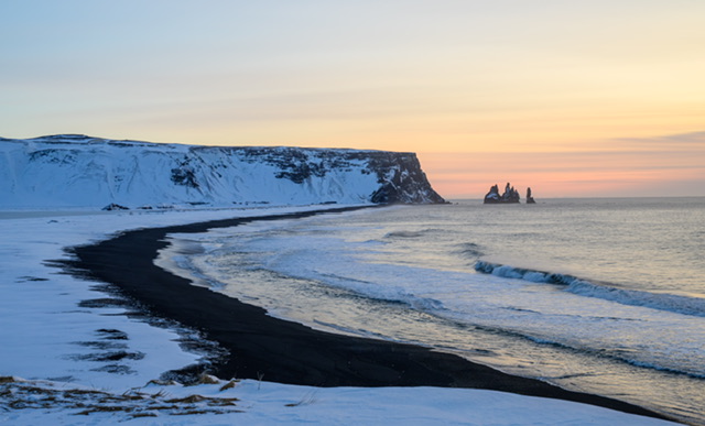
Moving further along, I could get a shot of a stack close by and try and capture the lines, or leading lines to the Reynisdrangar stacks in the distance.
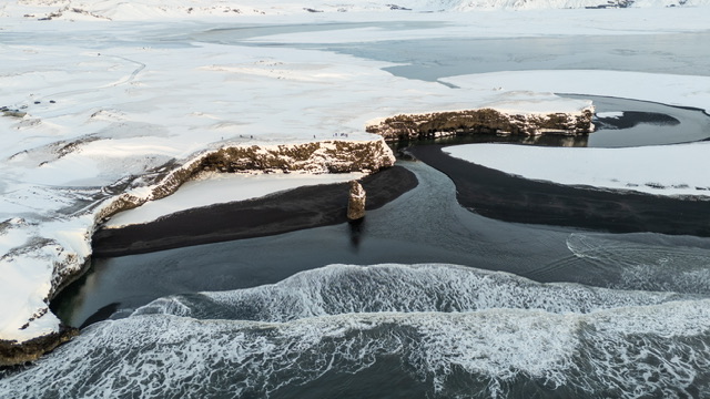
I decided to launch the drone as we had calm conditions.
I didn’t fly for long but grabbed the following shot which I’m pleased to have grabbed.
We were wrapping up at this point and some of the group had gone to shoot in the other direction.
Some of those photography colleagues have been here before so perhaps want to obtain some variation in their captures, but as this was my first visit, I was hooked on the sea stacks.
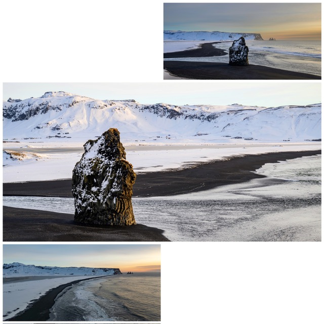
I did walk over and grab a couple of shots in the other direction (see one of them below) but it felt something of an anti climax given the dramatic scenery in the other direction.
How spoilt am I being given where I was? I guess that demonstrates what epic scenes are on offer in Iceland.
We gathered back at the van, loaded our stuff on and made our way out.
We were heading for Reynisfjara Beach.
En route, we stopped to shoot a hut on the side of a mountain, and there was a guy who’d made his was up to a cave and flew his drone over.
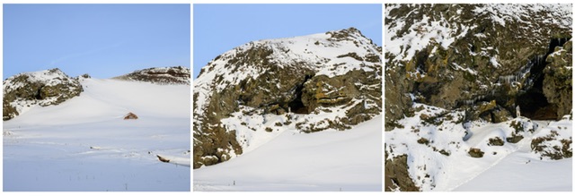
I had a quick wander round and tried to grab a shot showing the curves and shapes in the ice.
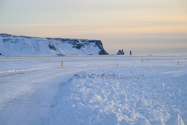
As I looked back down the road, I grabbed this scene of the sea stacks from distance and it gives you an idea of the snow on the road.
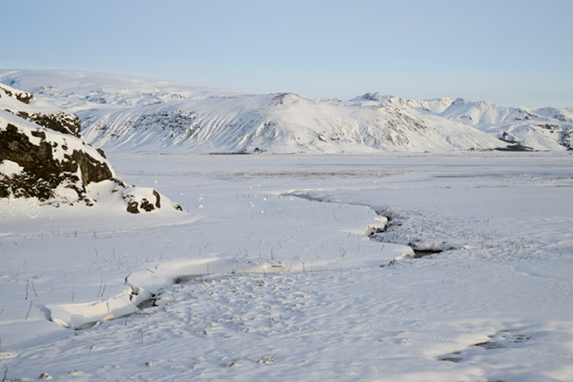
We had another roadside stop to shoot this church.
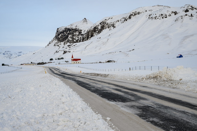
You will notice that churches in Iceland do seem to follow a similar design.
Reynisfjara Beach
We arrived at the next location which is the famous black sand beach at Reynisfjara.
We had some lunch in the café there so fuelled up to shoot more images, got our bags from the van and walked the short distance to the beach which is instantly recognisable if you’re someone who observes lots of Iceland images.
This beach is well known for its sea stacks and basalt rock columns but tragically for the ‘sneaker waves’ which can pull you into and out to sea.
Such is the danger that there are big warning signs and a set of lights to signal the risk level.
The location has been referred to as the “Chinese takeaway” since many tourists of that origin appear to ignore the warnings and perish, lost out at sea. Of course, it won’t just be Chinese tourists.
The beach to our left with the stacks was absolutely packed with tourists so we began shooting in the other direction.
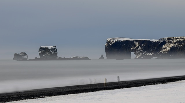
By using a slow shutter speed (61 seconds), I like the way the people on the beach are presented.
We wandered down onto the beach but kept close to where the snow met the sand.
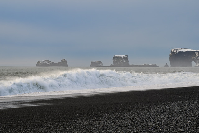
I grabbed a shot of the waves crashing onto the shore.
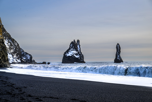
I then moved further forward on the beach to grab a shot of the sea stacks without any tourists in the scene.
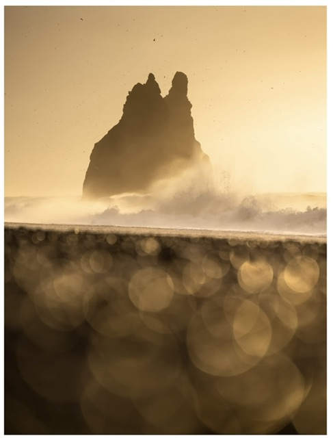
I’ve subsequently realised this location is where Nigel Danson captured his golden bokeh balls image (below):
It was impossible to get a shot of the basalt structures at the bottom of the cliffs but I wasn’t too bothered about it.
Two or three folks put their drone up and I was feeling a little nervous about it so I declared I wouldn’t launch.
Tragically, FOMO kicked in big time and up went the drone! 😳 I’m glad I did fly as I got a half-decent shot of the sea stacks.
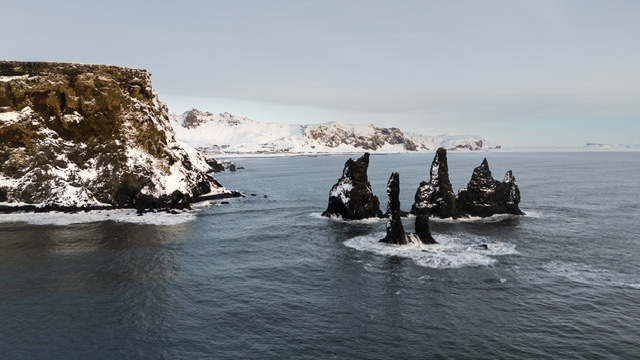
I tried to fly as far out as I dare to get separation in the stacks which I’ve almost perfected. Not quite though, as my perfectionists eye tells me!
I didn’t want to fly close to the stacks as there were a lot of birds flying around so it was a short flight and a quick landing.
That was a wrap.
At this point, you might think well that’s the day done. Two epic locations. But there would be another location to shoot before we finished.
We loaded the van and made our way to Fjadrárgljúfur Canyon.
Fjadrárgljúfur Canyon
About the canyon
Fjaðrárgljúfur (“feather river canyon”) is a canyon in south east Iceland. The Fjaðrá river flows through it.
The canyon has steep walls and winding water. It is up to 100 m (330 ft) deep and about 2 kilometres (1.2 miles) long. It is located near the Ring Road, not far from the village of Kirkjubæjarklaustur.
Its origins dates back to the cold periods of the Ice Age, about two million years ago. The canyon was created by progressive erosion by flowing water from glaciers through the rocks and palagonite over millennia.
A waterfall flows down the western side of the canyon, visible from an observation platform at the end of a one-mile hike up the eastern edge.
In May 2019, authorities closed the canyon to visitors after it appeared in the music video for Justin Bieber’s “I’ll Show You”. The resulting stream of visitors threatened to damage the canyon’s environment. Mercifully, neither Beiber or his fans were present when we were there!
The Shoot
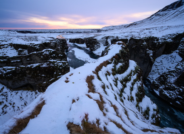
We made our way from the icy car park to a small bridge with a view up the canyon. This is where I took my first shot.
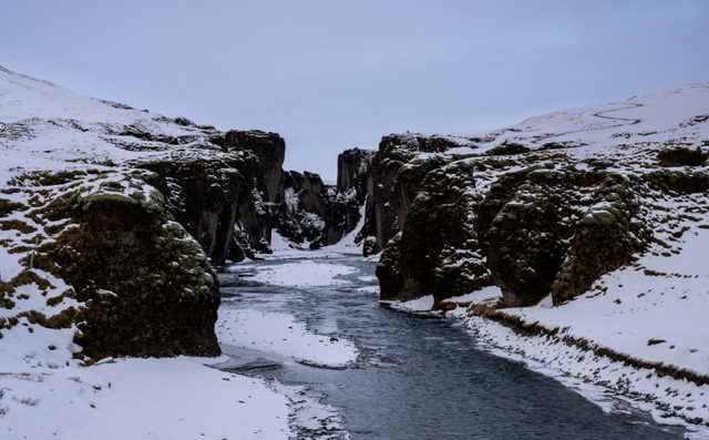
It was late in the day and with a drab sky this side (but some lovely sunset colours behind us), the images appear monochrome even though they’re not.
I decided to get the drone out as I was keen to fly it through the canyon.
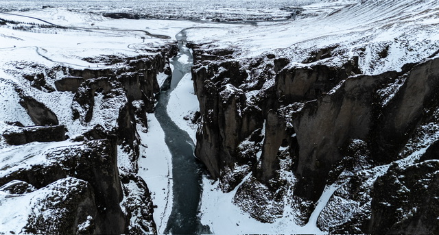
The set of images below show differing views of the canyon.
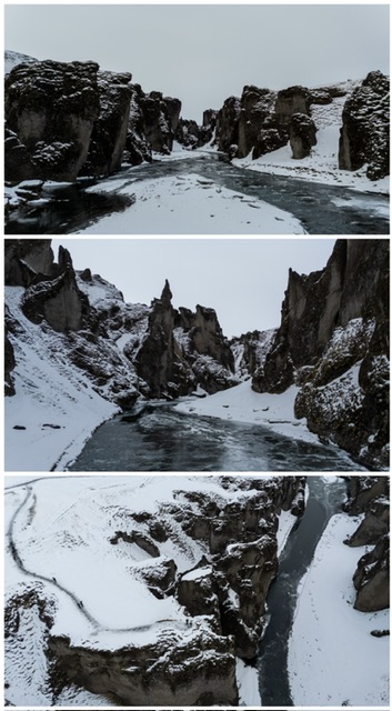
The first shot is as the drone is hovering low ready to advance through the canyon.
The second shot is deep into the canyon where the water is partially frozen. I flew the drone upwards from here and have some video footage which I hope to be some low grade version of a Star Wars scene!
The third image is looking down in the canyon.
I have another image which I really like which gives a view down the canyon.
After flying the drone, some of the group had retreated back to the van.
I asked Justin (Minns not Beiber) if I had time to walk up the path of the side of the canyon and he said yes.
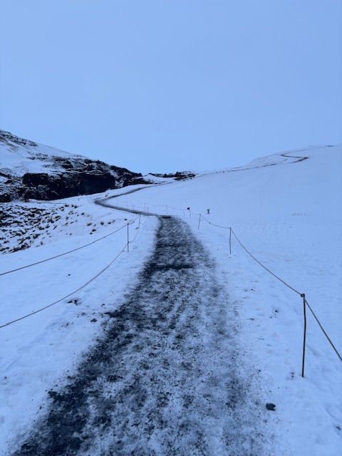
I made my way up at pace to find the first viewing area busy with three folks doing selfies, and therefore pressed on to the second viewing area to take some shots.
There is a third and maybe more viewing areas at the very top but I was conscious that peeps were waiting in the van and probably were looking forward to getting to the hotel as it had been a very long day.
To be fair, the light was falling now but there was still some colour in the sky looking back down the canyon and towards the bridge we had started shooting on arrival.
I went down to the first viewing area and took the shot below using my 14-30mm ultra-wide lens.
I made my way down the path at pace, much more pace than I had walked up.
The path was perilously icy and I had not thought to deploy the ice grips and on two occasions I very nearly went over.
I grabbed the rope on the side of the path and for some of the descent, held onto that so I could keep pace.
When I got to the bottom, I wasn’t quite the last one still out but there were only one or two others still out but they were packing up.
Back in the van, we made our way to the next hotel called Fosshotel.
And that really was a wrap.
Onwards and upwards…